Sunday, December 7, 2014

Mount Kinabalu- The First Attempt (Nov 2005)

This is a backdated post of my trip to Mt. Kinabalu in Nov 2005 almost a decade ago! Mt. Kinabalu, located in the supposedly autonomous state of Sabah in the Borneo part of Malaysia is Malaysia's highest mountain measuring 4095.4m in elevation above sea level. It is also the third highest peak in South East Asia after Hkakabo Razi in Myanmar (5881m) and Puncak Jaya in Western Papua, Indonesia (4884m). Mt. Kinabalu is a granite massive that lies in the Crocker Range that forms the backbone of Sabah's highlands in the Western Flank of the state. This mountain is one of the two primary reasons why tourist flock to Sabah, the other being Sipadan Island on the Eastern seaboard which supposedly boast some of the world's best diving sites.

Map of Sabah, the "doghead-like" Borneo state of Malaysia.

Sipadan Island which offers some of the world's best diving sites.

The expedition that formed this trip were myself, Ian, Peter, Alex & Rajpal. By now, all five of us would have had some mountaineering experience after hiking up some of peninsular Malaysia's G7 mountains. Mt. Kinabalu was the highest peak attempted by any of us at that point in time. Peninsular Malaysia's G7 were less than half its elevation.

We arrive in the capital of Sabah, Kota Kinabalu formerly known as "Jesselton" via a 2.5 hour Air Asia flight from KL. Spirits were high and we were all excited when we arrived in the "Land Below the Wind". It was also my first time in Sabah and Borneo despite it being an integral part of Malaysia! 


Some light rain greeted us in Kota Kinabalu as it was the rainy monsoon season then. The monsoon season in the west coast of Sabah lasts from November to February and rains can be very heavy causing severe flooding during this bad weather period. It was not very wise of us to plan an attempt on Malaysia's highest peak during this bad weather period indeed. Nevertheless, our excitement at an attempt to conquer Malaysia's highest point outshined the gloomy weather. 

We stayed in a backpackers lodge in the middle of town that night and would depart via bus to the foot of the mountain the next morning. The rain simply poured all night long signalling an unfavourable start to the journey. All we could do is hope that the next day would be a sunnier one. 

Morning arrived but the sun's rays were dim as a thick gray overcast hid most of the sun from the land...not a good sign for a start. Anyways, we had a quick breakfast and departed by bus to the foothill of the mountain. That journey through the Sabah highlands was a mesmerizingly beautiful one! The roads however, were narrow and winding and seemed unsafe at certain bends. Despite being one of Malaysia's most resource rich state, Sabah is still evidently impoverished in certain areas and still lack basic infrastructure such as tarred roads, electricity and clean water supply in the interior regions...how ironic. After a winding 2.5 hour journey through the mountains, we arrived at the Kinabalu Park headquarters, the is the very place where we get our guides and start our hike up the mountain. We paid up all necessary park fees, guide fees, insurance fees etc..and met up with our guide who is a minute pint sized Kadazan-dusun man named Mosilus. It was not a very ideal start for us time-wise as we arrived late in the morning at around 1030am and registration, payment etc took about an hour long. There are a few trails that lead up to the summit and the most popular one is the Timpohon trail being the shorter one and the other trail is the Mesilau trail which is the longer and more challenging trail. There is another least popular alternative trail called via Ferrata which requires technical climbing skills as rock climbing techniques are required to climb up the rockier side of the mountain. We took the Mesilau route for a challenge. 

 At the trailhead of the Mesilau Trail in the Kinabalu Park HQ.


The trek through the lower elevations of the mountain was a very refreshing one as cool mountain air from the lush greenery of the surrounding rainforest gave our oxygen-deprived "city" lungs some much needed cleansing. Although the Mesilau trail is much longer than the Timpohon trail, the consolation is that its steps are not as big because Timpohon goes up the steeper but shorter part of the mountain. One of the bad things of starting late is that you have less weather window and the bad weather starts coming in faster by noon. Thats exactly what happened to us. To make things worse I didn't even have a raincoat! By noon onwards, the clouds came in so did the rain and we were all battling the cold and the poor visibility. I was suffering from leg cramps as a result of the cooling down of my leg muscles by the rain. Alex and Rajpal were also suffering from these cramps. Due to my legs cramping very badly, I had to take many breaks in between and exposing myself to the pouring rain even more. I had to literally take baby steps up the mountain. After a 7 hour slog, we finally reached mid-way point which was where our shelter for the night is located, Gunting Lagadan hut. At that time, this mountain hut had no heating or even hot water. It was simply a roof over the head. The Laban Rata hut is a much better choice as it has heating and warm water in the showers. Choosing Gunting Lagadan didn't seem to be the right choice now that we were all soaking wet and shivering from the cold.

 Soaking wet by dusk in front of the Laban Rata mountain hut.

Drenched and weary after a day climbing through pouring rain. In Laban Rata guesthouse.

We had our dinner in Laban Rata which was crowded like a "pasar malam" (night market) and didn't even have a proper place to sit because there were tired hikers suffering from fatigue all over the place. The entire dinning hall had a "sweaty" stench as these late arrivals would just drop dead on the floor to take a few minutes of nap to regain composure. Dinner wasn't palatable that night and I didn't eat much to replenish the much needed energy for tomorrow's summit attempt. We hiked back up to Gunting Lagadan which was located at a slightly higher elevation from Laban Rata, after dinner to get some much needed rest for the night. Unfortunately for me I had a high fever that night after being exposed to the soaking rain and wind chill for the entire day. I couldn't sleep at all that whole night and was feeling nauseous. Things were not looking good for me. At 230am, Mosilus the guide came knocking at our doors as we had to depart early for the summit attempt in order to catch a glimpse of the supposed sunrise and more importantly to avoid the clouds coming in by late morning. There were already a few deaths on the mountain and the latest was that of a British girl who lost her way on the summit plateau because the cloud cover came in so fast and she strayed away from the main trail due to poor visibility. Her body was found a week later and post mortem showed that she died of hypothermia. Aki Nabalu which is what Mt. Kinabalu derives its name from means "Abode of the Dead" in the Kadazan-dusun language. We certainly didn't want to be permanent residents of this abode although the scenery from up here might be quite beautiful.  

The weather was again not on our side that morning, the God of the Rain summoned the clouds to continue pouring rain water on us. The climb up Kinabalu's rock face became a climb up a waterfall literally! Water was simply gushing down from the rocky trail ahead adding to the challenge of the already poor visibility and bone freezing wind chill. My condition became from bad to worse, and the bad weather was not helping my high fever get any better. I was like a drunkard climbing up the mountain just that I was not drinking. We arrived at the Sayat-Sayat huts (3668m), which was the last check point on the mountain. 


By this time I was almost completely drained of my energy and sanity. I was literally like a crazy drunk guy on the mountain and I even started hearing things in my ear...probably those "Abode of the Dead" people welcoming me to their beautiful home. Alex's condition wasn't good either as he was equally drained of energy. The summit was approximately 3 more hours away from this point (assuming in good weather). Our group had a quick discussion among ourselves. Since my condition was not improving and it was a risk for me to proceed further in a partially concious condition I opted to go no further than the Sayat-Sayat checkpoint. Alex also decided to stay put as he was in a similar condition as I was. Peter, Ian and Rajpal would proceed for the summit attempt in harsh weather conditions while Alex and I simpy KO-ed in a telephone booth at Sayat-Sayat, yeah thats right a telephone booth! London style...don't ask me why there's such a thing on that point of the mountain. We slept in the telephone booth to regain composure while waiting for the daring trio to summit and come back down. 

According to Ian's account, the climb up the summit was treacherous as the summit plateau was exposed to the stormy winds and the rain water droplets hindered vision, making the eyes very sore as it hit. Despite the bad weather, the trio made sturdy baby steps all the way to Low's Peak (4095.4m) which is the summit of Mt. Kinabalu and highest point in Malaysia. Well done to them! However that very day about half of the climbers turned back and didn't make it to the top due to the harsh weather (according to the checkpoint). 

 Ian on the summit plateau with South Summit in the backdrop. The wind had simply blown his raincoat apart.
Ian in front of the famed "Donkey Ears" on the summit plateau.

The trio met up with myself and Alex who were lying "partially dead" in the telephone booth while descending from the summit and we made our way down to Gunting Lagadan. Once back at the mountain hut, I jumped on the bed to have a much needed nap. By 11am we had to pack up and leave the mountain hut as that was the check out time. We made our descend through the Timpohon trail. It was a knee jerking descend as the steps were relatively big/high hence putting a lot of pressure on the knees. We were out of the mountain in 3 hours time, and along the way we saw pint sized Kadazan-dusun guides making their journey up the mountain carrying baggage 3X their size on their heads! That really put me to shame! 
Our expedition team at Laban Rata on the descend.

To date Mt. Kinabalu remains the only mountain that defeated me on that very climb. It was due to several poor decisions from climbing during the peak of monsoon, to not bringing a raincoat, to choosing that unheated hut (Gunting Lagadan) and not eating enough. This failed trip for me was certainly a blow to my mountain climbing ambitions and put me on the backseat to do some self reflection before planning for future climbs. One thing I learned is that there's no easy mountain! Even though there could be thousands of tourists from the old to the young summiting Mt. Kinabalu every year, it doesn't mean that this mountain is an easy one. A mixture of the wrong conditions would create a recipe for disaster and I learned it the hard way. Thankfully there were no injuries to anyone or it could have been much worse and probably put an early end to my mountain climbing days. Kinabalu was a great teacher to me and a reminder that the will of man is nothing in the face of nature's fury! 

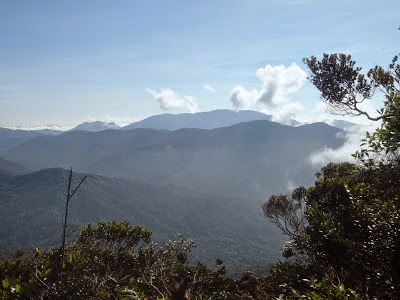
Mt. Kinabalu hiding behind the clouds as seen from Kota Kinabalu.

Wednesday, December 3, 2014

The G7 Mountains

In Malaysia, it is common to hear about the G7 mountains among the hiking community. The G7 mountains are basically seven of the highest summits above 7000 feet in Peninsular Malaysia. Although elevation-wise they might be insignificant to those in the Himalayas or the Andes, the challenge posed by these 7 mountains are no less tormenting. The G7 definitely deserves deep respect from anyone who are attempting as they are not for the faint hearted and people have actually died while attempting to conquer their summits. The challenges posed by the G7s are very different from those posed by the ice mountains of Tibet or the 14ers of Colorado. Over here, elevation is not so much a problem hence its quite rare for hikers to face altitude sickness problems. However, among the problems that one can anticipate is such as getting lost in the dense tropical rainforest. This is indeed a very real danger as the Malaysian tropical rainforest is very lush and dense with flora.
The lush and thick vegetation of the Malaysian rainforest floor.

On less trodden routes, one might even have to make their own trail through the thick vegetation. Though the mountains here don't see temperatures below zero, the fast changing mountain climate does pose a challenge. You could be trekking through the jungle floor in scorching hot and humid conditions only to be poured with torrential rain moments later at higher elevations. This drastic change in local climate and temperature can rapidly weaken a person's body hence causing him or her to easily fall sick. Not to forget the Malaysian rainforest is infested with blood sucking leaches which can suck up to 10X their original size! If you thought that by wearing anti-leach socks would solve the problem, you just thought wrong! Believe me that these sneaky creatures can some how find their way to the most delicate and private parts of your body!
Blood thirsty leaches can suck up to 10 times their original size.

If you don't mind the leaches anyhow, I'm sure you will definitely mind the sandflies as their sting will cause a severe itch that can send you into a scratching frenzy the whole night long!
Sandfy bites are very itchy and leaves bad reddish scaring.

If you are lucky enough or should I say unlucky enough (depending on how you see it) to bump into the occasional tiger or elephant or snake or bear or a combination of them, you are just in for another run for your life encounter.
A wild Malayan tiger on the hunt.

So with this said, you probably will start to believe me that the G7's level of difficulty is indeed very misleading if you simply judged it based on its elevation.

The following is a brief description of all the G7 mountains according to their elevation and degree of difficulty:


Gunung Tahan (2187m) G1
Difficulty Rank 4.5/5 from Kuala Tahan 4/5 from Merapoh


Mount Tahan is the highest of the G7 mountains which also means its the highest peak in Peninsular Malaysia. It is located right in the heart of Taman Negara (Malaysia's largest National Park) which is claimed to be the oldest rainforest in the world. The word "Tahan" literally means endurance in Malay. As its name suggest, only those who can endure the long and arduous journey through its thick rainforest terrain can make it to the top. The name itself strikes fear in those who are seeking to conquer its summit. Mount Tahan is the only G7 mountain located outside of the Titiwangsa Main range which forms the back bone of Peninsular Malaysia. In fact, Mount Tahan is located in the Tahan Range which is part of the Tenasserim Range that stretches all the way from Southern Thailand. There are two main routes that lead to the summit of this mountain namely the Kuala Tahan trail and the Merapoh trail. The former typically takes a week long while the latter takes between 3-5 days. It is also possible to start in Kuala Tahan and end in Merapoh and vice versa. The National Park is usually closed during the Northeast monsoon period (Nov-Feb) as heavy rain causes flooding. The degree of difficulty of this mountain depends on which trail is used. The Kuala Tahan route is certainly the more challenging one as it is longer in distance and crosses through several of Taman Negara's major rivers. This route is only recommended for very fit and experienced hikers. Meanwhile the Merapoh route is shorter but goes up the steeper section of the mountain. Overall, a high level of fitness is required to attempt Mount Tahan.


Gunung Korbu (2183m) G2
Difficulty Rank 4.5/5


Mount Korbu is certainly no easy pushover. Just gazing at its steepness and massiveness might make you wanna turn back at the trailhead. This hell of a mountain promises to give you a hell of an experience! Just getting to the mountain itself is already a challenge as you will need to traverse through thick rainforest in challenging terrain. In the low lying areas where the ground is more wet, you will notice vampire leaches chasing after you. By half way point your legs would be bloodily stained by leach bites. At mid way point, you are bound to be bitten by "invisible" sandflies which will result in a nastily itchy sting that gets you scratching all night long. The worst sandfly zone is at Kem Agas (aka Kem Kijang) which happens to be the 2nd camp site. Just when you thought things might get better, you are proven wrong when you stand face to face with the Chuban Wall which is a near vertical cliff on the mountain and undoubtedly the most challenging part of the trek! The Chuban Wall is what defines Korbu hence climbing up this challenging section is certainly a "Baptism of Fire" for any potential Korbu sumitteer. There are fixed ropes to assist hikers in climbing up the Chuban Wall however they are poorly maintained and have not been replaced in a long time. Those who have acrophobia (fear of heights) will find it hard to get past this section as the view of a 1000m drop is exposed here. Once passed this section, there are 2 more false peaks to get passed before reaching Korbu's summit which is the 2nd highest in Peninsular Malaysia. From here, you could continue onwards to Gayong's summit for another 1 hour through a flat ridge that connects the two mountains.


Gunung Yong Belar (2181m) G3
Difficulty Rank 3/5 from Cameron Highlands 4.5/5 from Gayong


Yong Belar makes up one of the three mountains of the Trans Titiwangsa trail. This trail is a very popular trail that crosses the Titiwangsa Main Range as the name suggests. Traditionally the trail start from Mount Korbu onward to Mount Gayong and Mount Yong Belar before ending in the Blue Valley of the Cameron Highlands. It is also possible to do a reverse of that trail starting in Yong Belar and ending up in Korbu. Although there are no big challenges posed by Yong Belar, one cannot take it for granted. There are many reports by hikers of encounters with wild animals such as elephants, snakes and wildboars on this mountain. There is a point on this mountain called "Three Boundaries" because it is the exact point where the boundaries of the three states namely Pahang, Perak and Kelantan meet. This point is marked by a stone marker to denote the significance of that place. The start of the journey to Yong Belar through the Blue Valley is very scenic. This valley is located at the very edge of the Cameron Highlands just about where the trailhead to Yong Belar is.


Gunung Gayong (2173m) G4
Difficulty Rank 2/5 from Korbu 4.5/5 from Yong Belar


Gunung Gayong is also known as the birthplace of "silat gayong" a traditional Malay martial art. This mountain is basically Malaysia's version of the Shaolin Monastry sans the temple and the monks. Legend has it that there was once a mysterious Malay warrior who went up to the summit of Gayong to meditate for one year. In the process he invented "silat gayong" to defend himself from the wild animals that inhabit the mountain. This mountain has a very broad peak which looks like a turtle from afar. No wonder it is a suitable place to practice martial arts given sufficient flat surface on the peak. The view from its peak is magnificent as one will be able to see Mount Korbu in all its glory. To get to Gayong's summit, you will first have to summit either Korbu or Yong Belar as Gayong is located right in the middle of these two mountains. The route from Korbu will be the easier option as it is connected by a relatively flat and easy ridge to hike. This is the reason I ranked this mountain as the easiest of the G7 but don't get deceived by this rank as you will have to conquer either Korbu or Yong Belar first to get here. The route from Yong Belar goes through a valley called "Lembah H2O" so named because it is muddy and is strewn with puddles of water the entire trail. What this also means is that you will be trekking through leach territory although the consolation will be being able to find water source easily. This route is very difficult hence requiring a high level of fitness and is indeed the toughest part of the Trans Titiwangsa trail.


Gunung Chamah (2171m) G5
Difficulty Rank 5/5


Located in the middle of the Royal Belum forest, this is undoubtedly the toughest G7 mountain to conquer simply because the route that leads to its peak is through thick virgin rainforest. It is so remote that if you were to trek out of Chamah it would take no less than 4 solid days of non stop trekking through the rainforest. The Royal Belum forest is also famous for wild tiger and elephant sightings and stumbling upon tiger footprints is quite common. The risk of getting lost in the virgin jungle is very real hence it is always wise to get an experienced guide and stick together with the hiking convoy as trails can sometimes be very undefined. A good 4 days of trekking is usually spend getting to the mountain itself due to its remoteness. On the mountain proper, there are several false peaks that lies along the way and this can be very demoralizing. Unfortunately, the summit lies at the very end of the ridge of false peaks. This mountain should only be attempted by hikers who have very high levels of fitness because the many provisions that you would have to carry for the long expedition will make your backpack very heavy. It is also recommended that you register with the nearest police station in Gua Musang so that the authorities are aware on the expected duration you will be in the jungle (in case they need to conduct a search and rescue operation). Typically this mountain is attempted along with Ulu Sepat in what is called the Trans Chamah-Ulu Sepat trail and can take between 7-10 days long depending on fitness. This mountain is usually left as the last one on the G7 list because it is better to gain some G7 experience from the easier lot of the G7s.


Gunung Yong Yap (2167m) G6
Difficulty Rank 3.5/5


Yong Yap is a pyramidal shaped mountain. It is undoubtedly the most symmetrical mountain in Malaysia. From afar, it has a very sharp pointed peak. To get to the trailhead of this mountain one would need to ride in a 4WD vehicle from the starting point in Kampung Lasah orang asli village (takes 2 hours) or from Pos Brooke (takes 40 minutes). This is a very bumpy ride as it goes through the old logging trail which is untared and muddy. This ride will save you a lot of trekking energy as you wont need to trek through the rainforest to get to the mountain proper however if you happen to get car sick then it doesn't help your cause. Once you are dropped off the 4WD, the trek starts and the route is practically heading all the way up! Your calf muscles will have to be very strong to endure this long and steep uphill trek. The trek downhill can be very punishing as it can take a toll on your knees. The jungles of the Yong Yap area is one of the few places where the Malayan Tiger still roams freely. There have been cases of tiger attacks on this mountain in the past. The two fatal ones that I can recall was a lone logger who was attacked while walking on the logging trail and another case involving an Orang Asli (aborigine) being devoured by a hungry old tiger. It is advisable to stay within the group at all times and avoid straying alone in the jungle here.


Gunung Ulu Sepat (2161m) G7
Difficulty Rank 4/5


The last of the G7 but not necessarily the easiest. Also located in the Royal Belum forest, this mountain is as remote as Mount Chamah. Typically hikers would do a Trans Chamah-Ulu Sepat to bag two peaks in one trip. But make no mistake, this trail is one of the most difficult mountain treks in the entire Malaysia if not the most difficult! Getting to this mountain itself is a major hurdle as you would have to travel a long way just to reach the trailhead. There are two ways to reach the trailhead which is located at Pos Kemar. The first way is by riding a 4WD from Sungai Siput to Kampung Lerlar while the 2nd way is by taking a boat across the Temenggor Lake from Grik's Trojan Jetty to Pos Kemar Jetty (1 hour) or alternatively from the Banding Jetty to Pos Kemar Jetty (2 hours). From the Pos Kemar Jetty, you will require a 4WD to get to the trailhead at Pos Kemar. Travelling here is already an adventure by itself. This mountain is also well renowned for its little menace "sandflies" and hikers coming here are quite unlikely to get away unscathed by these nasty creatures. Dont be surprised if you see elephants climbing along the way as the slopes of this mountain are rather gentle at certain points. As you approach the summit, the gradient can be very steep and you might even have to scramble on all four at certain points as it is near vertical.


*Disclaimer: These descriptions are merely the opinions and judgement of the author and should not be taken as an official benchmark as fitness level and hiking experience of each person varies from one to another. All the G7 mountains should be treated with utmost respect as they certainly demand a high degree of fitness for anyone planning to attempt it!

Sunday, November 30, 2014

Destruction of the Cameron Highlands

I was deeply sadden to hear about the Cameron Highlands mud floods which occurred on the 5th and 6th of November 2014. This was the second time a mud flood of this magnitude ravaged the Bertam Valley which lies in the highlands. A year earlier a similar mud flood struck and 3 casualties were reported. This time around, it was reported that there were 6 casualties from this disaster but unofficial reports suggested that the toll was higher. The video below shows the mud flood ravaging through Kampung Baru Ringlet which is a town located in the Bertam Valley:


 The Cameron Highlands has always been a very special place for me as this is the very place I started my high altitude adventures. It is very sad indeed to see the destruction of this pristine highlands as I have always known it for its lush greenery and gentle rolling hills surrounded by the majestic blue mountains in the distance.

This is the view of the picturesque highlands that I've always known. 

Throughout the years, agri farms have dominated the landscape of the Cameron Highlands. Even the mountain air is no longer cool these days and the number of tourists have been dropping consistently.

In the past few years since I last hiked in the highlands, massive vegetable farms have been  rapidly sprucing up like mushrooms after the rain. The organic food industry has become a booming industry as most Malaysians have become more health concious throughout the years. Generally, as people in Malaysia get wealthier, they become more willing to spend on organic food which supposedly contains zero pesticide hence good for health. A lot of entrepreneurs saw the potential of this organic food industry and quickly capitalized on the growing demand. They rushed up the Cameron Highlands to acquire fertile virgin jungle land to raise vegetable farms, some through illegal means. Since the organic farming business was so good, it raked in huge profits for the farmers and the authorities that govern the land. Man being man are always cursed with the insatiable desire for more thus opening the floodgates to a whopping 6000 acres of land being cleared legally and illegally in the highlands.  
Land clearing on the slopes of Brinchang in the Cameron Highlands not too far away from a holiday resort. 

Years of rampant land clearing have led to the accumulation of a lot of silt in the Sultan Abu Bakar Dam which is part of the Ringlet water reservoir catchment. When the land is cleared, the loose earth when exposed to torrential rain, flows into streams and eventually into catchment reservoirs and deposits as silt. These silt used to just sit at the base of the Ringlet water reservoir but after years of deposition, the volume of silt have built up to a point it almost filled the entire reservoir with silt. Even the waters of the catchment reservoir became an obvious muddy brown which is a clear indicator of the dam silting up to the brim. 

  The murky brownish waters of the Ringlet reservoir is a sign of heavy siltation.

Towards the year end, in the months of November-December, Peninsular Malaysia is hit by a meteorological phenomena known as the Northeast monsoon which brings with it heavy downpour. The Cameron Highlands being the mountainous back bone of the peninsular receives the full brunt of torrential rains. This is precisely when disaster struck. On the 5th of November 2014, the rain poured heavily and continuously for more than 5 hours hence triggering the disaster. As the Sultan Abu Bakar dam can only withstand not more than 80% of its catchment capacity and the siltation deposits had probably taken up close to 50% of its capacity, the dam could not cope with the additional hydrostatic loads on its walls and had no choice but to open the floodgates. The result was the devastating mud flood which ravaged through the mountain town of Ringlet and the rest of the Bertam Valley.

Cartoon depicting how land clearing leads to siltation of the reservoir resulting in reduced water catchment capacity of the dam.

The map shows the extent of the area ravaged by the mud floods.
Fast flowing floodwaters gave villagers no time to escape to safer areas with their belongings.
The trail of destruction left behind by the mud floods in the Ringlet town in Cameron Highlands.
The inhabitants of Kampung Baru Ringlet suffered massive loss of property due to damages caused by the mud flood.

SJK C Bertam Valley was not spared from the mud floods.
The damage to school property was so extensive that it forced the cancellation of the SPM examinations for Form Five students in Cameron Highlands.

The SPM examinations which were supposed to be held at the school was forced to be cancelled in the wake of the destruction and students were relocated to other parts of the region to take the exams.
The Sultan of Pahang inspecting the destruction in the Cameron Highlands in Nov 2014.

Following the destruction due to the mud floods in Cameron Highlands, there was the usual finger pointing when figuring out who the main culprit was. There were suggestions by certain quarters that it was the doings of the illegal workers from Bangladesh, Myanmar & Indonesia that were responsible in the land clearing. However, if you think about it these illegal workers merely follow orders and wont simply toil to clear land if not instructed to do so with no incentives. Once again the innocent villagers were being hoodwinked by those in power to find the scapegoat. The Malaysian media was flooded with news of the destruction of the highlands and politicians were promising millions of dollars for the clearing up of the Cameron Highlands but that doesn't solve the long standing issue of environmental destruction as the greed of man and their disrespect towards mother nature will cause her to bite back with a promise of devastation.

It is my only hope that mother nature is resilient and will recover from any destruction if given the chance to but man must learn to place deep respect for mother nature and the mountains instead of being blinded by the temptation of material gains otherwise we are bound to witness another round of mud floods in the Cameron Highlands which will only get worse next time around. 


Saturday, November 29, 2014

Im Back Blogging After a Long Long Lapse

Its been more than 4 and a half years since my last post on this blog but I guarantee you that there's been a whole lots of excitement in my high altitude life all these years hopping from peak to peak. I just finally managed to find some inspiration and some time (well not really that much time) to update my missing high altitude adventures throughout the years. Thanks to my long time mountain buddy, Peter who mentioned to me that he stumbled upon my blog while Googling something about Mt. Korbu recently. If not for him, I wouldn't even remember that this blog still existed.

So much has happened in my life ever since the last post on Mt. Tahan which I climbed in year 2005! Can you believe it? Its been almost a decade since I conquered Tahan! How old I'm getting now :P

                         Graduated from KTJ in June 2006

Anyways, just to update y'all, after 2 good years studying my pre-U in Kolej Tuanku Ja'afar (Cambridge A-Levels), I went to the Colorado School of Mines to further my studies. To be honest, I also got an offer from the Imperial College in London to do Geology. However I stood with my choice to pursue Petroleum Engineering at the Colorado School of Mines partly because London is flat and wet while Colorado is smecked right in the Rocky Mountains and is definitely da place to be for a mountain man!

 In May 2010, after 4 topsy turvy years of studying and adventuring in the Americas, I graduated with my Bachelors Degree in Petroleum Engineering.

                           Graduating in the mountains!
                Yup, thats ma degree in Petroleum Engineering ;)
                                To infinity & beyond!
                  The hat throw is a must for graduation ceremonies.
                 Thats right, its a one way ticket...back to Malaysia!

I went back to Malaysia to start my career with PETRONAS, who I am very grateful to as my sponsors for my education. Believe it or not, when I got my offer letter I was posted to KERTEH!! The place that I grew up as a child! Sweet childhood memories I had of that place indeed. The Kerteh of today is slightly different from those days where there was practically NOTHING but none the less exciting! Anyways, I became a Well Intervention Engineer in charge of Peninsular Malaysia Operations which is mostly offshore Terengganu. I did a lot of cool stuff such as slickine fishing, Coiled Tubing methanol soaking and running tractors with E-Line if you know whats that all about haha! Well I guess all you need to know is that Im serving d nation by enhancing oil & gas production to optimum levels!

         In front of a slickline unit which is used to intervene a well.
                      I travel offshore with these cool choppers.

After 3 good years in Kerteh, I've transferred back to d big city of KL where I'm based in Malaysia's national icon the Twin Towers. Its good that I can see the breathtaking view of the Titiwangsa Mountain Range on a clear day from my office window as it never fails to inspire me to push towards greater heights in my career!

               Based high up in the sky in the iconic Twin Towers.

Anyways, thats what I've been up to in a nutshell for all these years. I was so occupied building my career and doing other important things in life that I almost forgotten about this blog. But the mountains are always a part of me and when I drift a bit too far away, they will start calling and then begins another high altitude adventure with another tale to tell.

*I promise to update more on my missing mountain adventures throughout the years in the consequent posts. Stay tuned for more!